Showing posts with label The Atlas of the World. Show all posts

Tuesday, June 12, 2012

Atlas of the People's Republic of China : Administrative divisions


Monday, June 11, 2012

Atlas of the People's Republic of China


China - People's Republic of China
The People's Republic of China is a country located mostly in East Asia, with a smaller proportion of its area located in Central Asia. It has borders with ► North Korea, ► Russia, ► Mongolia, ► Kazakhstan, ► Kyrgyzstan, ► Tajikistan with ► Gorno-Badakhshan, ► Afghanistan, ► Kashmir, disputed by China, ► Pakistan and ► India, ► Nepal, ► India, ► Bhutan, ► Myanmar, ► Laos and ► Vietnam, its own special administrative regions of ► Hong Kong and ► Macau. Furthermore it has maritime borders with ► South Korea, ► Japan, ► Taiwan (Republic of China (claimed by China) and the ► Philippines. It claims the ► Paracel Islands and the ► Spratly Islands, whch leads to additional borders with ► Indonesia, ► Malaysia and ► Brunei. With over one-fifth of the world's population, the PRC has the world's largest population. At over 3.7 million square miles (over 9.5 million km²), the PRC is the third or fourth largest country by area. China has five autonomous regions: ► Tibet, ► Xinjiang, ► Inner Mongolia, ► Ningxia and ► Guangxi.

Short name  China
Official  name People's Republic of China
Status Independent country, statehood since 1766 BCE
Location East Asia
Capital 北京[4] (Beijing)
Population 1,315,844.000 inhabitants
Area 9,596.960 km²
Major  languages Mandarin Chinese (official), variations of Chinese and minority languages. Main other language is Cantonese.
Major  religions Chinese folk religion (combination of Buddhism, Confucianism and Taoism), Non-religious
More information China, Geography of the China, History of the China and Politics of the China
More  images China - China (Category).


Monday, June 11, 2012

Saturday, June 9, 2012

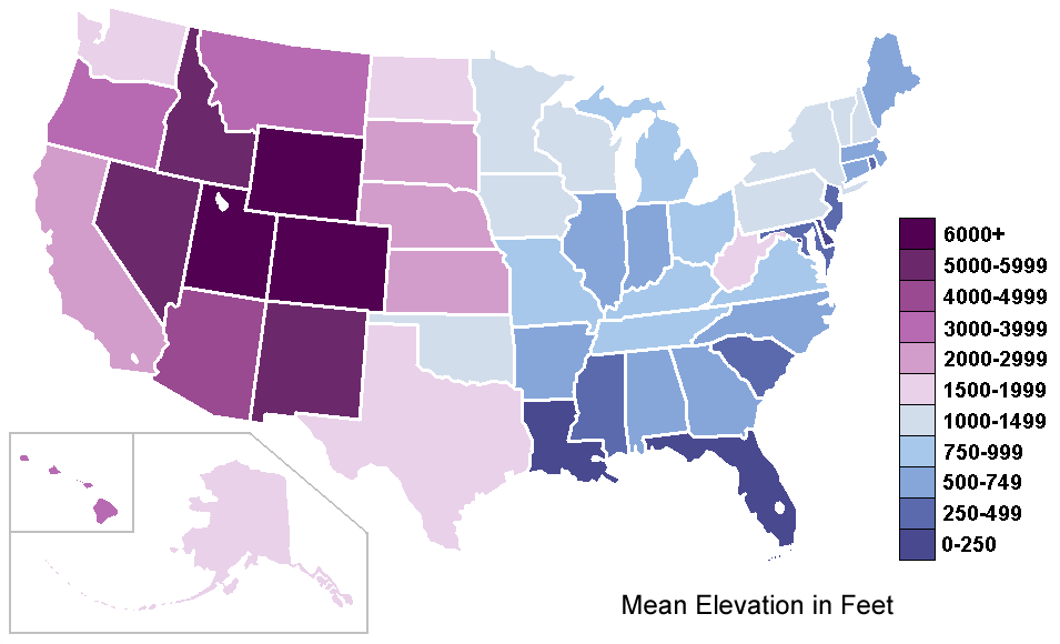
Atlas of the United States - United States of America


United States - United States of America
The United States of America, also referred to in short form as the United States, the USA, and colloquially as America, is a country in North America that extends from the Atlantic Ocean to the Pacific Ocean, and shares land borders with ► Canada (including ► Quebec) and ► Mexico. To the west of Alaska lies ► Russia, to the (south) west of Florida ► Cuba, the ► Bahamas and ► Bermuda are located. The United States is a federal constitutional republic, with its capital in Washington, D.C. It consists of fifty individual states and a number of territories and other federally administered areas. At over 3.7 million square miles (over 9.6 million km²), the United States is the third largest country by total area. It is the world's third most populous nation, with over 300 million people.
Asssociated commonwealths are the ► Northern Mariana Islands and ► Puerto Rico, other organized unincorporated territories are ► Guam and the ► United States Virgin Islands. The unorganized unincorpated territory with self-government is ► American Samoa. The unincorporated unorganized territories are ► Baker Island, ► Howland Island, ► Jarvis Island, ► Johnston Atoll, ► Kingman Reef, ► Midway Atoll, ► Navassa Island, ► Wake Island and the incorporated unorganized territory is ► Palmyra Atoll. The United States have the ► Guantanamo Bay Naval base on ► Cuba. ► Palau, the ► Marshall Islands, and ► Micronesia are freely associated with the United States. Maritime borders are shared with ► Japan and the ► Philippines.

Main minority languages:
Español: Estados Unidos de América Los Estados Unidos de América es un país de América del Norte conformado por una federación de 50 estados y un distrito federal. También tiene varios territorios dependientes ubicados en Antillas y Oceanía. Su forma de gobierno es la de una república presidencialista y federal. Cuarenta y ocho de los estados están en la región entre Canadá y México. A estos estados se les llama, más o menos formalmente, los Estados Unidos continentales o contiguos y en ocasiones los 48 de abajo. Alaska está en la zona noroeste de América del Norte, separada de los otros estados por el territorio canadiense de Columbia Británica. El archipiélago de Hawaii, el estado número 50, se ubica en el Océano Pacífico. La capital federal, Washington, se sitúa en el Distrito de Columbia, entre los estados de Maryland al norte y Virginia al sur.


Short name  United States
Official  name United States of America
Status Independent country since 1776 (recognized 1783)
Location North America
Capital Washington DC
Population 301,348,000 inhabitants
Area 9,631,420 km²
Major  languages English (de facto official), Spanish and other minority languages
Major  religions Protestantism, Roman Catholicism
More information United States, Geography of the United States, History of the United States and Politics of the United States
More  images United States - United States (Category).


Friday, June 8, 2012

National Atlas of the United States


The National Atlas of the United States is an online atlas published by the United States Department of the Interior.

Since it is a publication of the United States Government, the atlas and the maps contained therein are in the public domain.

A printed edition was issued in 1970; it is now out-of print but the Library of Congress has posted it online as part of its American Memory collection.

Information used to develop the National Atlas of the United States is also used in conjunction with Canadian and Mexican information to produce continental-scale tools such as the North American Environmental Atlas.


Friday, June 8, 2012
,

Atlas of Republic of India

The Republic of India is a country in South Asia. It is the seventh-largest country by geographical area, the second most populous country, and the largest democracy in the world. India has a coastline of over seven thousand kilometres, bounded by the Indian Ocean on the south, the Arabian Sea on the west, and the Bay of Bengal on the east. India borders ► Pakistan to the north-west; ► China (with ► Tibet), ► Nepal to the north; and ► Bangladesh, ► Bhutan to the north-east; and ► Myanmar to the east. In the Indian Ocean, India is in the vicinity of ► Sri Lanka, ► Maldives and ► Indonesia are to the south. In the north west, India claims sovereignty over parts of ► Kashmir.


Short name     India
Official  name    Republic of India
Status    Independent country since 1947
Location    South Asia
Capital    नई दिल्ली (New Delhi)
Population    1,103,371,000 inhabitants
Area    13,166,414 km²
Major  languages    Hindi, English (both official), 21 regional official languages[8]
Major  religions    Hinduism, Islam, Christianity, Buddhism, Sikhism, Jainism and others
More information    India, Geography of India, History of India and Politics of India.

Tuesday, June 28, 2011

,

The Atlas of Pakistan : Notes and references

General remarks:

* The WIKIMEDIA COMMONS Atlas of the World is an organized and commented collection of geographical, political and historical maps available at Wikimedia Commons. The main page is therefore the portal to maps and cartography on Wikimedia. That page contains links to entries by country, continent and by topic as well as general notes and references.
* Every entry has an introduction section in English. If other languages are native and/or official in an entity, introductions in other languages are added in separate sections. The text of the introduction(s) is based on the content of the Wikipedia encyclopedia. For sources of the introduction see therefore the Wikipedia entries linked to. The same goes for the texts in the history sections.
* Historical maps are included in the continent, country and dependency entries.
* For Burma, see Myanmar; Great Britain and Northern Ireland, see United Kingdom; Ivory Coast, see Côte d'Ivoire; Pridnestrovie, see Transnistria; Taiwan, see China, Republic of; Timor-Leste, see East Timor.
* The status of various entities is disputed. See the content for the entities concerned.
* The maps of former countries that are more or less continued by a present-day country or had a territory included in only one or two countries are included in the atlas of the present-day country. For example the Ottoman Empire can be found in the Atlas of Turkey.

1. ↑ Romanization: Pākistān - Islami Jumhuriyah Pākistān.